Agate Falls Scenic Site in western UP closed through fall
Repairs and improvements to trestle bridge also require reroute of ORV trail
-
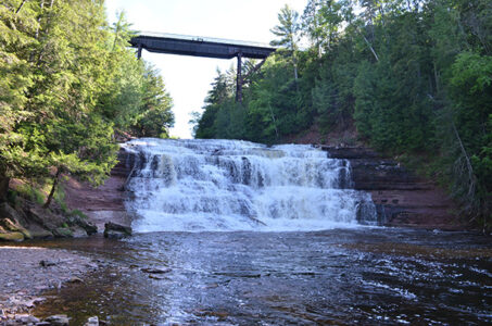
- Agate Falls Scenic Site
-
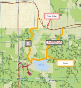
- AgateFallsRerouteMap

Agate Falls Scenic Site
Agate Falls Scenic Site, a popular western Upper Peninsula attraction managed by the Michigan Department of Natural Resources Parks and Recreation Division, is temporarily closed through late fall for essential repairs and improvements to the site’s trestle bridge.
This closure, which is slated for completion Nov. 1, 2026, also includes rerouting an off-road vehicle trail that runs through the property off state Highway M-28 in Ontonagon County. Agate Falls Scenic Site is known for its picturesque views and activities including fishing, hiking and ORV riding.
“With the work taking place directly above the pathway and overlook, the site is closed to ensure public safety,” said Dan Dowdy, unit supervisor with the DNR Parks and Recreation Division.
The DNR is using a Federal Highway Administration Recreational Trails Program grant to pay for the site’s repairs and improvements, which are expected to cost $1.6 million. This program provides funds to states to develop and maintain recreational trails and trail-related facilities for both nonmotorized and motorized recreational trail uses.
ORV reroute

AgateFallsRerouteMap
Reroute map for ORV trail at Agate Falls Scenic Site
Along with closing the scenic site, the DNR also has rerouted a 4.6-mile section of ORV SB Route. Riders will need to travel on a detour totaling 18.6 miles until the scenic site reopens in November, weather depending.
The reroute begins at Mile W, then continues to Calderwood Road, which becomes Bond Falls Road, until it reaches “LL” on the trail. Riders can view this reroute in more detail by visiting the DNR’s interactive ORV trail and route map.
“This reroute is a local ‘club route’ and is known as the CW,” said Carly Graff, western Upper Peninsula trails specialist for the DNR Parks and Recreation Division.
About Agate Falls Scenic Site
Considered one of Michigan’s most picturesque waterfalls, Agate Falls is located along the middle branch of the Ontonagon River. A half-mile trail at the scenic site provides access to an observation platform with views of the top of the falls. The trail offers views of overhead railroad trestles and passes through a tunnel under M-28.
When the scenic site is open, parking, vault toilets, an adjacent paved trail and a picnic area are available at the adjacent Michigan Department of Transportation roadside park, which is generally open early May through late October.
The falls are created as the river finds its way over an extended shelf of terraced sandstone. The resulting waterfall is a broad band of interlacing cascades and small falls nearly 40 feet high. When the site is open, visitors can reach the observation platform via an accessible foot trail.
Learn more about this scenic site – and find other nearby U.P. attractions managed by the DNR – by using the DNR’s Recreation Search at Michigan.gov/RecSearch.
For more information about ORV riding in the U.P. and throughout the state – Michigan has more than 4,000 miles of state-designated ORV trails, scramble areas, (eligible) county, state forest and national forest roads – visit Michigan.gov/ORVInfo. You’ll find license and trail permit information, an interactive ORV trail and route map, and more.
Before visiting any DNR-managed location, it’s always a good idea to check the latest closures due to weather-related events and planned improvement projects and repairs occurring at DNR facilities around the state. Any revised construction timelines will also announced on the DNR’s closures webpage at Michigan.gov/DRNClosures.
Note to editors: Accompanying photos are available below for download. Caption information follows.
Agate Falls: Agate Falls Scenic Site, a popular western Upper Peninsula attraction managed by the Michigan Department of Natural Resources Parks and Recreation Division, is temporarily closed through late fall for essential repairs and improvements to the site’s trestle bridge.
ORV reroute: Along with closing the scenic site, the Michigan Department of Natural Resources also has rerouted a 4.6-mile section of ORV SB Route. Riders will need to travel on a detour totaling 18.6 miles until the scenic site reopens in November, weather depending.
Regional News

Tornado activity surpasses yearly average as peak season begins

Michigan State Police enter annual best looking cruiser contest
MDARD takes steps to protect Michigan from new world screwworm
MARQUETTE — The Michigan Department of Agriculture and Rural Development (MDARD) recently announced new domestic ...
Cheboygan man sentenced for threatening judge, prosecutors
LANSING – Barry Hopkinson, 61, of Cheboygan, was sentenced to three to 15 years in prison on Thursday, June 18 ...