How a fight for Toledo gave Michigan the U.P.
-

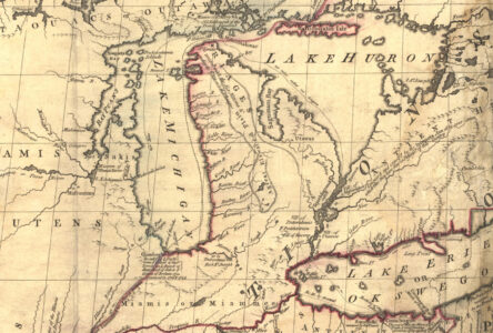
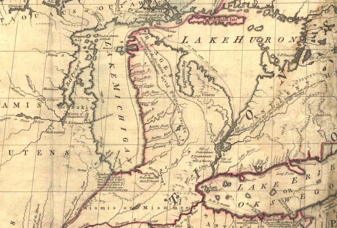
- Map showing the Toledo Strip, a piece of land claimed by both Michigan and Ohio for decades around the turn of the 19th century. (Altered from U.S. National Atlas for Wikimedia Commons by rmhermen)
-
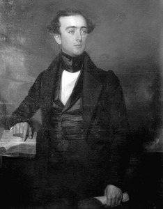
- Stevens Thomson Mason, who became the acting governor of the Territory of Michigan in his early 20s, was called the “Boy Governor.” The young man helped guide Michigan through the Toledo dispute to statehood and was elected its first governor. (Detroit Publishing Company photograph collection, Library of Congress)
-
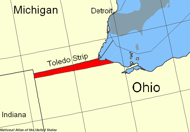
- This late 1700s map drawn by John Mitchell likely contributed to the boundary conflict between Ohio and Michigan. (Library of Congress)
-
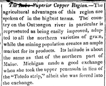
- Only a few years after Congress gave Michigan the Upper Peninsula, colonizers of the state discovered that the area was rich in copper. This brief article published in the Fort Wayne Times in 1846 says that Michigan made out well in the deal, despite being “forced into the exchange.” (File, Fort Wayne Times and Peoples Press)
Map showing the Toledo Strip, a piece of land claimed by both Michigan and Ohio for decades around the turn of the 19th century. (Altered from U.S. National Atlas for Wikimedia Commons by rmhermen)
Editor’s note: This article is one of a series reflecting on America’s history. The Daily Press will continue running articles about the country’s past periodically until the 250th anniversary on July 4.
A complicated boundary dispute over a 468-square-mile strip of land can be attributed to poor maps and stubborn colonists. It resulted in Congress favoring Ohio and giving the Upper Peninsula to Michigan as a consolation prize when it “lost” the Toledo War to achieve statehood.
Back at the end of the 18th century, the United States of America was comprised of states and territories, the total area of which was about one-third of the present-day contiguous United States. Little by little, growing westward, areas applied for statehood, and leftover land was reorganized into different territories.
Conflicts may have been expected when France and Britain and Spain all tried to colonize North America and displace the native peoples, but there were also border discrepancies between territories of the United States.
Land surveying and cartography was imperfect in a strange new world.

Stevens Thomson Mason, who became the acting governor of the Territory of Michigan in his early 20s, was called the "Boy Governor." The young man helped guide Michigan through the Toledo dispute to statehood and was elected its first governor. (Detroit Publishing Company photograph collection, Library of Congress)
Before the Northwest Territory was carved up, it included the areas currently known as Ohio, Indiana, Illinois, Michigan, and Wisconsin and the northeastern part of Minnesota.
Ohio became the first from the region to upgrade to statehood in 1803, but from before then until decades later, there were differing opinions on where the line separating Ohio from the territory to the north lay.
The Ordinance of 1787 that established the Northwest Territory – so-called because it was an area northwest of the Ohio River – made reference to a geographic line. It stated that Congress reserved the right to form one or two states “north of an east and west line drawn through the southerly bend or extreme of Lake Michigan.” When a state reached a population of 60,000 inhabitants, it could be granted into the country and would have the liberty to form its own state constitution and government.
When the people of Ohio set their boundaries, they drew the northern line not along a latitude running due east from the southernmost point of Lake Michigan; instead, the line was drawn on a diagonal so that it would intersect with Maumee (then called Miami) Bay on Lake Huron. Doing so included the lakeside port that would later become the city of Toledo. They included such phrasing reportedly in case Lake Michigan extended further south than previously thought. Looking at existing maps didn’t help – the prominent map at the time was the John Mitchell map, which had been drawn in 1755 and was highly inaccurate.
Though Congress granted Ohio statehood, no federal representatives surveyed the boundary claim at that time.
This late 1700s map drawn by John Mitchell likely contributed to the boundary conflict between Ohio and Michigan. (Library of Congress)
When Ohio separated from the Northwest Territory, the land left was called the Indiana Territory. By 1805, the Michigan Territory was organized and separated from Indiana – but was still not a state.
In the early 1800s, most of what is now the Lower Peninsula of Michigan was seen as wasteland. Settlements were happily made along the water and toward the southern parts of the territory, but the inland regions were not desirable. Considering Michigan needed to meet that 60,000 population requirement to achieve statehood and representation, they needed every head count they could get. Many of its residents were concentrated in the southeastern part of the territory – near Maumee Bay.
In 1816, the commissioner of the general land office directed the surveyor-general to mark the line between the State of Ohio and the Territory of Michigan. The deputy sent to establish the line, William Harris, used the information included in Ohio’s constitution, not the original verbiage that would have favored Michigan. Instead of marking a line running due east from Lake Michigan as suggested in the Ordinance of 1787, Harris favored Ohio’s claim and went on a diagonal up to Maumee Bay.
Displeased, Michigan immediately protested, and Congress sent another surveyor, John Fulton. Fulton found that the border favored Michigan by falling about eight miles south of the Harris line.
The Territory of Michigan had been considering villages down to that point as their own and was exercising its jurisdiction there. Monroe County and Lenawee County, both parts of Michigan, extended down to what became called the Fulton Line.
Only a few years after Congress gave Michigan the Upper Peninsula, colonizers of the state discovered that the area was rich in copper. This brief article published in the Fort Wayne Times in 1846 says that Michigan made out well in the deal, despite being "forced into the exchange." (File, Fort Wayne Times and Peoples Press)
The strip in between the two lines – a long, narrow triangle that became known as the Toledo strip – was claimed in ways by both sides.
Ohio operated as if the port at Maumee was theirs, and began building canals to connect Lake Erie with the Ohio River.
Despite the discrepancy, it was almost a “agree to disagree” situation, and no major conflict erupted for years.
During the 1820s and ’30s, the Michigan Territory grew in population. Immigrants had learned the land was fruitful, and they built roads and bridges and schools and towns. When Michigan decided to apply for statehood under territorial governor Stevens Thomson Mason in the 1830s, the land debate had to be settled.
In 1832, Congress ordered another boundary survey. This one showed that the line should fall south of Maumee Bay, which would place the port – and some of Ohio’s canal project – in Michigan.
People of Michigan voted in favor of organizing into a state in 1832, but it took a couple stressful years, and they did not get what they wanted. Though Michiganders believed they rightfully had claim to the Toledo strip as per the Ordinance of 1787, the State of Ohio made their case louder – after all, they had numerous delegates in Congress, while Michigan had no voting members.
“President (Andrew) Jackson wanted to satisfy Ohio. He was up for reelection, so he wanted to make both sides happy and offered a compromise to Michigan,” wrote Aidan Stead for Michigan Tech. “This compromise ignored Congress’ surveys and gave Ohio the Toledo Strip, gave Michigan the western three quarters of the now Upper Peninsula, and offered Michigan statehood.”
In simple terms, that is true, but Michigan did not accept this offer willingly.
A hairier portrayal is described in “Michigan as a Territory” by Byron M. Cutcheon. He explained that Governor Mason – then only in his early 20s and called the Boy Governor – gave a rousing speech to Michiganders on Sept. 1, 1834, accusing Congress of being influenced by politics and stating that Michigan, which by this point had well over 60,000 residents, had the right to be granted statehood.
One Lucius Lyon, a Michigan politician as well as a government surveyor, argued to Congress that Michigan deserved the Toledo strip. It was “a most able, complete and exhaustive presentation of the case, which has never been answered, just overcome by superior force,” according to Cutcheon.
“Ohio, with her great power and influence, was able to hold off the admission of (Michigan as a) state until the Toledo strip had been wrested from her,” Cutcheon wrote.
Former President John Quincy Adams was on Michigan’s side, and in 1833 said: “Never in the course of my life have I known a controversy of which all the right was so clearly on one side and all the power so overwhelmingly on the other.”
The scuffles surrounding the boundary dispute, now collectively called “The Toledo War” despite not being a war in the traditional sense, have been referred to as “embarrassing” by multiple sources and even as the “second most embarrassing moment in Ohio history” by a blog on Ohio History Connection, a nonprofit associated with the State Historic Preservation Office and the Ohio archives.
Most accounts consider the start of the war to be when Ohio announced its intention to survey and remark its northern boundary as described in the state’s constitution – that is, the slightly diagonal line extending upwards to the northernmost cape of Maumee Bay. This was at the beginning of 1835. Michigan was still not yet a state.
The Ohio governor formed a new county, Fulton, which included the disputed area.
Governor Mason insisted that Michigan’s rights had been violated, but as a mere territory, the claim lacked certain authority.
Michigan created the “Pains and Penalties Act,” declaring it a penal offense for officials not assigned by the United States or Michigan to attempt to exercise jurisdiction within the territory. Since the Ohio surveyors would have to cross through Michigan counties to plot their line, Governor Mason ordered the commander of the territorial militia, General Joseph W. Brown, to use armed forces to resist encroachments.
“We cannot submit to an invasion on our soil,” General Brown addressed the Michigan militia, according to the Centennial History of Michigan. “We are determined to repel with force whatever strength the State of Ohio may attempt to bring into our territory to sustain her usurpations.”
By April, a militia from Michigan and a militia from Ohio were facing each other from opposite sides of the Maumee River. However, commissioners from the President arrived before Ohio “invaded.” The feds said that the boundary-marking by Ohio representatives could proceed.
The Ohio surveyors started from the west, and began to measure towards Maumee Bay. However, when they reached the border of Lenawee County in Michigan Territory, law enforcement and a posse began to make arrests in accordance with the Pains and Penalties Act.
“A few arrests were made, but the Ohio commissioners and head surveyor made a timely escape,” states the Centennial History. Upon reaching an Ohio town, “they reported that their party had been fired upon by the Michigan militia and had just escaped with their lives. This account, with exaggerated details, was widely circulated and produced much excitement in Ohio.”
In July of 1835, Joseph Wood, a sheriff from Michigan, went to Toledo to arrest Two Stickney, a man who had violated the Pains and Penalties Act. Stickney stabbed him. It was a minor wound from which Wood recovered, and is believed to be the only blood drawn during the Toledo War.
In retaliation, Governor Mason ordered a militia to Toledo, but “when they arroved, the Michiganders discovered the Ohioans had fled to the safety of Ohio,” states the Michigan History Center.
In the fall of 1835, the voters of Michigan ratified its constitution. They elected the young Mason as their first official State Governor. Michigan became an example of a state “breaking into the Union,” rather than inducted by enabling act, as Cutcheon put it.
But in order to receive federal funding, boundaries had to be agreed upon by Congress.
On September 26, 1836, 49 delegates from across the Michigan Territory met at the Washtenaw County Courthouse in Ann Arbor for the First Convention of Assent. The federal government was in favor of giving the Toledo strip to Ohio, and as a compromise offered Michigan the remainder of the Upper Peninsula. (At the time, just the eastern tip of the U.P. belonged to Michigan Territory.)
Michiganders did not like this deal. The U.P. was not seen as valuable – its abundance of ore was yet unknown – and it was seen as unfriendly, occupied by Indians and fur traders.
Finally, Michigan had to concede that in order to achieve statehood and the associated rights and funding, they couldn’t keep waiting for Ohio and the federal government to hand over the Toledo Strip.
A second convention was held on December 14, again in Ann Arbor. The delegates begrudgingly accepted Congress’s terms, even writing in their resolution:
“…it was better to be humiliated and to secure the civil and religious liberties inherent in statehood than to engage in an idle, unprofitable and hopeless contest for a boundary which is assuredly and forever lost to us.”
The Second Convention of Assent became known as “the Frostbitten Convention,” not only because of the chilly temperatures in Michigan in December, but also because of the cold reception the agreement received. Michigan had seemingly come out on the losing end by not retaining the Toledo strip.
The new state was officially signed into the union by the President on Jan. 26, 1836.
The first few years of Michigan’s statehood were bitter. Michiganders felt that the preferred piece of land had been stolen from them – they had been given 9,000 square miles of hostile, frozen land instead of a thriving port.
The animosity faded somewhat over time, mollified by the discovery of resources in the U.P. and overshadowed by the later Civil War.
Though parts of the Harris boundary that was ultimately accepted had been plotted in 1817, 1835, 1837 and 1842, the physical markings had disappeared by the 20th century. The U.S. Geological Survey mapped the line again in 1915 and placed 72 granite markers along the boundary from Indiana to Lake Erie. Adhering to the strict line created a place called Lost Peninsula – a small bit of land jutting north in Maumee Bay, technically a part of Michigan but connected only to Ohio.
Local News

Summer creativity

The wrong kind of fire truck

Garth Bluff Grocery to reopen
School leaders urge budget deal as July 1 deadline nears
LANSING — The Michigan Association of School Boards (MASB) and Michigan Association of Superintendents and ...
Convicted felon from Garden arraigned on with felony weapons, drug charges
