Lake effect snow piles up in region
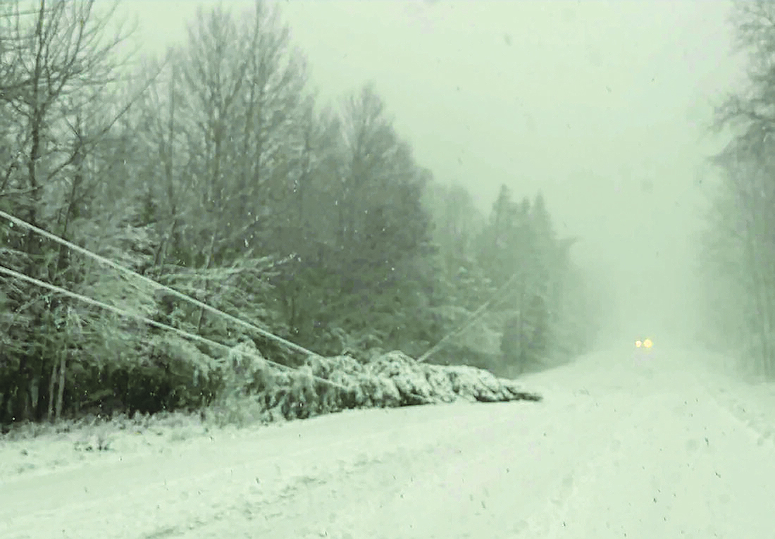
Severe winter weather hit the Upper Peninsula late Tuesday and continued into Thanksgiving Day. The wet, heavy snow, coupled with high winds, brought down power lines in the Copper Country area, knocking out power to thousands throughout Houghton, Ontonagon, Keweenaw and Baraga counties. This photo was taken Wednesday morning on M-203 near the intersection of Lakeshore Drive in Houghton County. (Paula Porter, for the Daily Mining Gazette)
LANSING, Mich. (AP) — Residents of the Great Lakes region had a snowy Thanksgiving, as a weather system dropped precipitation across the area, particularly in the northern Upper Peninsula.
Snowfall that began Wednesday persisted Thursday with winds and snow bands out of the north and northwest. A blizzard warning was in effect in Alger County, east of Marquette, until 7 p.m. Thursday.
The heaviest snowfall was expected to hit west of Munising, according to the National Weather Service, with up to 13 inches of additional of snow accumulation possible.
Lily Chapman, a meteorologist with the National Weather Service in Marquette, said 15 inches of snow were measured at her office Thursday morning. Near Bessemer, Chapman said the National Weather service received reports of more than 18 to 28 inches of snow.
“It varies pretty quickly depending on things like elevation or where any of our stronger bands have been able to line up,” Chapman said.
While the snow stopped in the Upper Peninsula for the most part on Thanksgiving Day, reports from the Keweenaw County Road Commission show that 24 inches of snow fell between Tuesday night and noon Thursday, according to the Daily Mining Gazette in Houghton. The NWS office in Negaunee Township reported similar numbers, with a total of 15 to 20 inches in the Houghton area and 31.3 in Twin Lakes in the 48-hour period, the Daily Mining Gazette reported.
What is lake effect snow?
Lake effect snow is characterized by thin bands of clouds that can produce heavy snowfall. Some areas can see much more snow than others nearby thanks to the narrow bands.
The phenomenon occurs when cold air from Canada is blown over the warmer water of the Great Lakes: Superior, Michigan, Huron, Ontario and Erie. Warm air from the lakes pushes the moisture in the sky higher into a zone most conducive to snowfall. The clouds that form as a result can dump 2 to 3 inches per hour and sometimes more.
The weather particularly affects Michigan, Ohio and New York, but lake effect snow can also happen over other large bodies of water, like the Great Salt Lake in Utah.
About 10 miles west from Bessemer near Montreal, Wisconsin, the National Weather Service reported 33 inches of snow in one location early Thursday morning. Roy Eckberg, a meteorologist with the National Weather Service in Green Bay, said the elevation of the area creates an even better environment for clouds to create snow.
“So you not only have the lake effect, you’ve got the lift of the terrain,” he said. “So that area can get some pretty interesting snow totals like this event.”
Dangerous driving
The traveling bands of lake effect snow can cause sudden and extreme whiteouts, making driving hazardous. Travel was difficult across the Upper Peninsula on Thursday with low visibility, Chapman said.
Additionally, strong winds of up to 45 mph posed a threat of creating large snow drifts over roads and power outages. More than 1,000 power outages were reported near Houghton, about 100 miles west of Marquette on Thursday morning, according to the utility provider the Upper Peninsula Power Company.
Similar power outages were reported by Consumers Energy on the coast of Lake Michigan near Holland, about 170 miles west of Detroit. The National Weather Service of Grand Rapids expected about two inches of snow Thursday with high gusts of wind of 45 mph near the lakeshore. The weather service warned of slick roads.
The lake effect snow was expected to ease west to east. However, a different storm system is forecasted to blanket the Great Plains and Midwest regions with snow starting today heading into the weekend. The National Weather Service said Chicago could see six inches of accumulated snow through Sunday.
About 2 to 3 inches of snow were reported near Buffalo, New York, on Thanksgiving morning, and a lake effect snow warning was in effect until early Saturday morning.
———
The Daily Mining Gazette in Houghton contributed to this report.


