Snowstorm affected roads, power, businesses
-
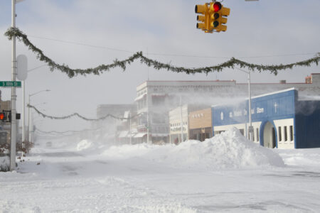
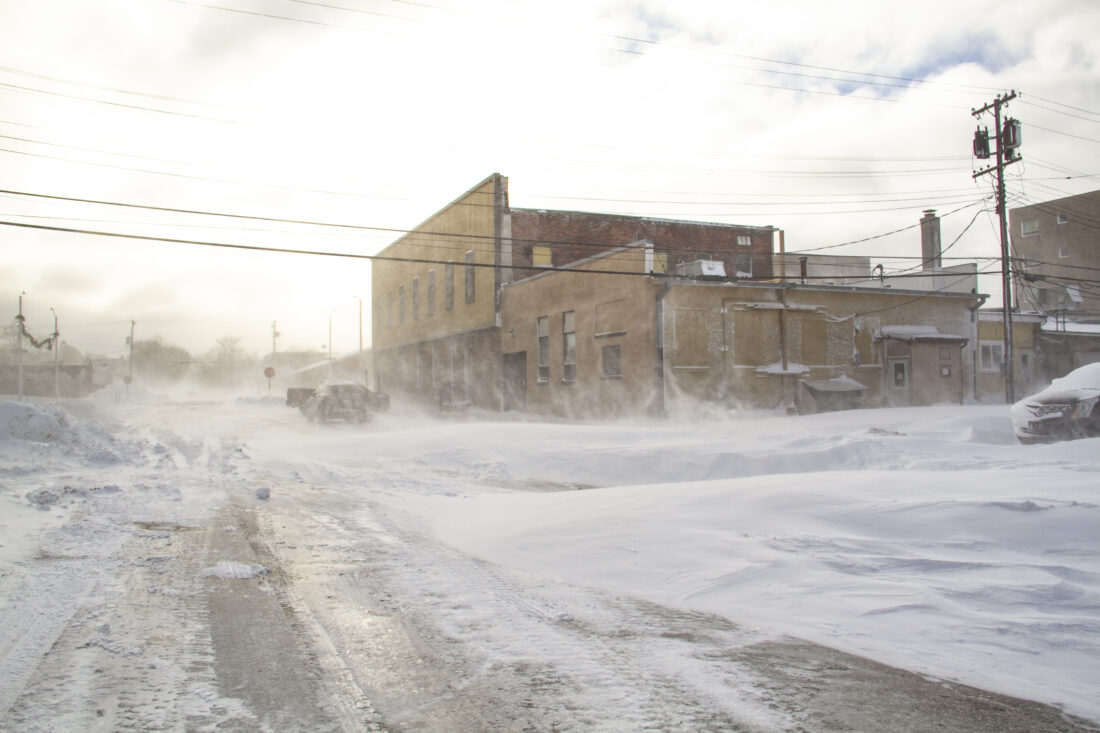
- Plowed snowbanks and gusting snow are seen in this view of Escanaba’s Ludington Street on Monday afternoon. (R. R. Branstrom | Daily Press)
-
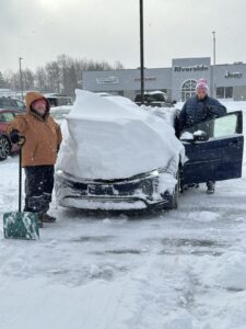
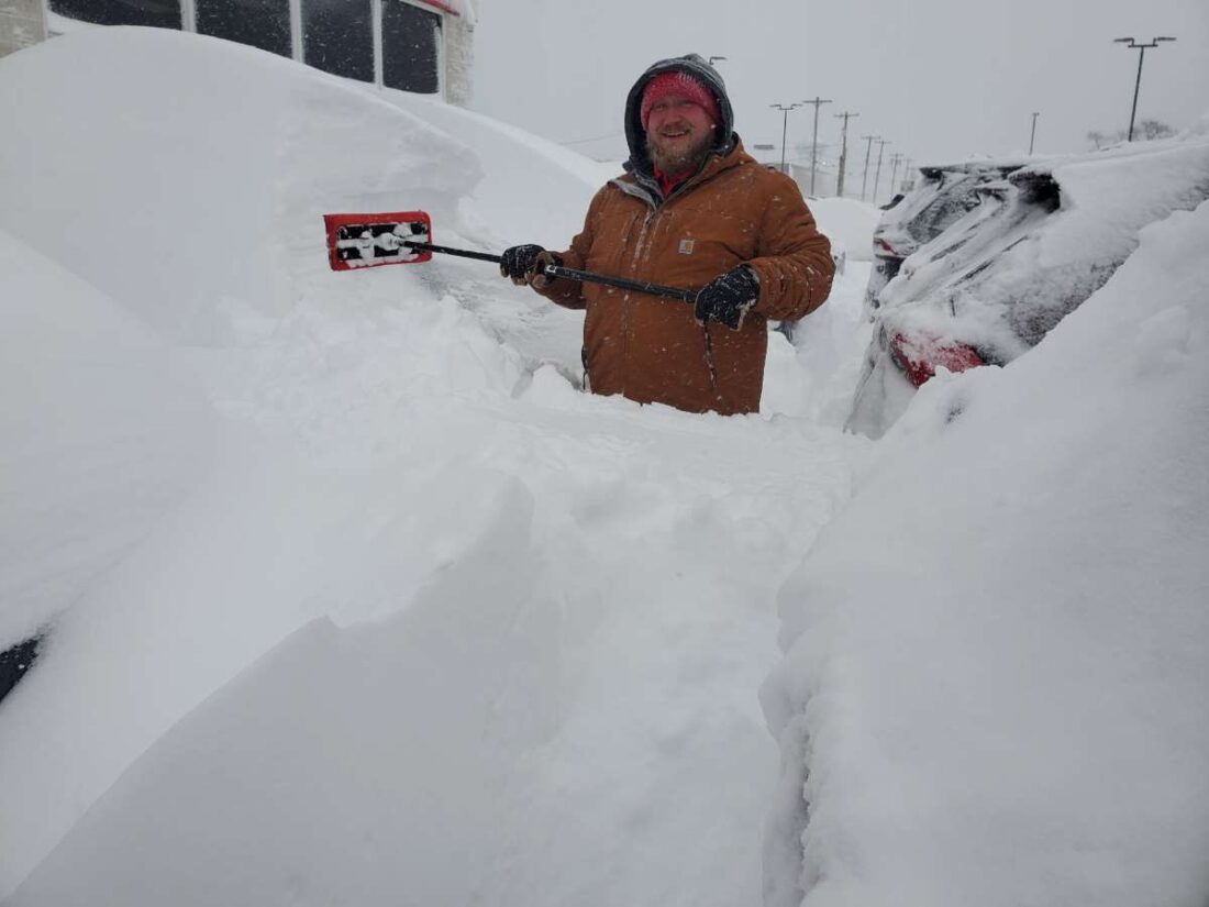
- At Riverside Toyota in Escanaba, salesmen Patrick Peerenboom (left) and Mitchell Johnson (right) stand next to a 2026 Prius they have freed from the snow, while the car still holds the height of a drift on its hood. (Photo courtesy of Matt Wegner)
-

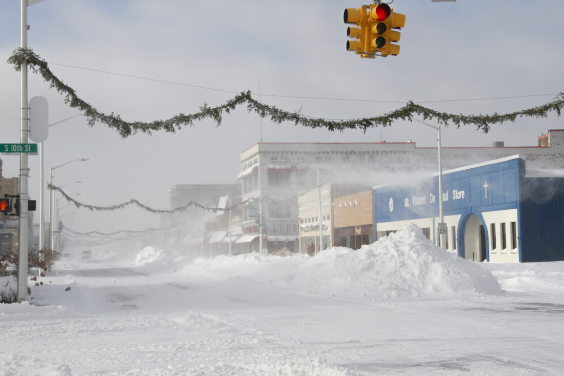
- Even after the snow had stopped falling and roads had been plowed, new drifts continued to form as strong winds blew the snow around. Shown is the Daily Press from North Sixth Street around 1:30 p.m. Monday. (R. R. Branstrom | Daily Press)
-

- Patrick Peerenboom pauses for a photo Monday while digging vehicles out of 5-foot drifts at Riverside Toyota in Escanaba. (Photo courtesy of Mitchell Johnson)
-
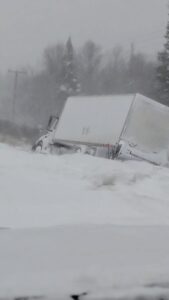
- Many vehicles needed to be towed after trying to travel in poor conditions Monday, including this truck in the ditch on M-35 near Rock. (Photo courtesy of Dave Pepin)
-
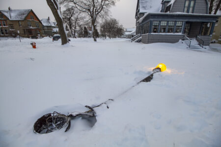
- On Monday, a downed but illuminated lightpost on South Seventh Street in Escanaba lies in the snow. (R. R. Branstrom | Daily Press)
-
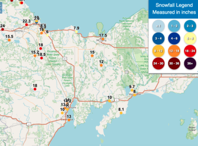
- This image on weather.gov shows reported snowfall amounts in the central Upper Peninsula. A range of recordings, even in the same towns, indicates the variation in depth caused by high winds.
-
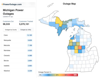
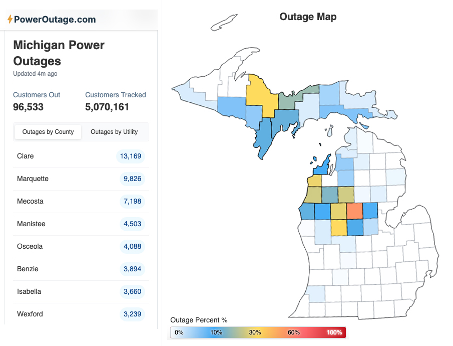
- Homes and businesses in the Upper Peninsula and the northwestern Lower Peninsula lost power from the storm that hit the area Sunday night into Monday. (Image from poweroutage.com)
Plowed snowbanks and gusting snow are seen in this view of Escanaba's Ludington Street on Monday afternoon. (R. R. Branstrom | Daily Press)
ESCANABA — Much of the Upper Peninsula and the northern Midwest experienced blizzard conditions Sunday into Monday, with most effects seen Monday as the storm system blew eastward.
It’s been some time since Escanaba, part of a “banana belt” that tends to get less snowfall, saw this much snow at once. High and variable winds caused drifts several feet high in many places, but an average estimate places about a foot of snow in Escanaba, and areas in Marquette County got more than 2 feet, according to the National Weather Service.
After weather the past few days had been above freezing, existing snow had mostly melted away by the time the recent storm reached the U.P. Locally, precipitation started as a wintry mix Sunday afternoon and changed from sleet to snow at night.
The storm system had begun southwest of the Great Lakes, and swept in over the region as it moved eastward.
It affected different regions in various ways, said meteorologist Ryan Metzger at the National Weather Service office near Marquette. The southern end of the Midwest got thunderstorms and heavy rain instead of snow.
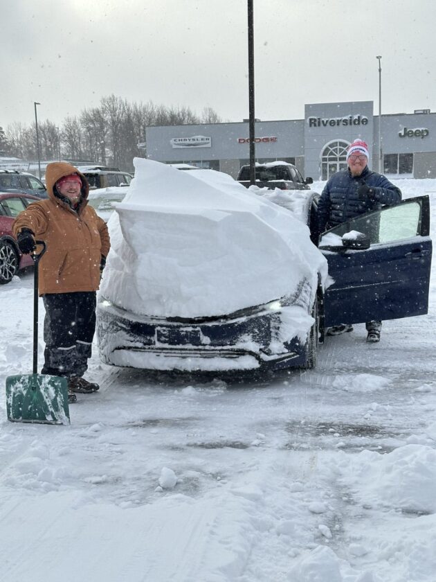
At Riverside Toyota in Escanaba, salesmen Patrick Peerenboom (left) and Mitchell Johnson (right) stand next to a 2026 Prius they have freed from the snow, while the car still holds the height of a drift on its hood. (Photo courtesy of Matt Wegner)
“It brought a lot of severe weather to Illinois and Indiana and Ohio as well. The same storm system, they were kind of on the warm side of it; we were on the cold side of it,” Metzger said.
Though the U.P. has seen the worst of it now, the storm is not dying but continues on its northeast track and will bring “interesting” weather to other parts of the U.S. and Canada, as Metzger put it.
“This is a very, very powerful storm,” Metzger said. “It brought a lot of very strong winds. There’s places in the northern U.P. gusting into the 50s (mph), for sure.”
At Delta County Airport, the wind didn’t exceed 10 mph until about midnight Sunday — or Monday morning — and then was pretty intense most of the day Monday, with sustained winds of about 20 mph from 7 a.m. to 4 p.m., and the strongest gusts of 38 mph recorded about noon.
Downed trees knocked out power around the U.P. and left tens of thousands of homes and businesses without electricity in the morning Monday. However, crews were able to restore service within a few hours in several areas.
Even after the snow had stopped falling and roads had been plowed, new drifts continued to form as strong winds blew the snow around. Shown is the Daily Press from North Sixth Street around 1:30 p.m. Monday. (R. R. Branstrom | Daily Press)
Though they began the day with 2,200 outages, UPPCO had reduced that number to 908 power outages by about 2 p.m. Monday. As they serve 58,576 customers, this amounts to just 1.55% of their total customers who were out of power at midday. The greatest number were in Marquette County, where 573 of 14,401 — 4% — were out of service. In Delta County, 214 customers lost power, representing 2.9% of the 7,315 served by UPPCO.
We Energies, which serves a larger pool of people, had 5,419 customers without power at the same point — about 2 p.m. Monday. The most reported outages came from near the Wisconsin border — there were 838 We Energies customers without service in Dickinson County, 967 in Menominee County, 800 in Iron County and 706 in Gogebic County. In Vilas County, Wis., 1,838 homes and businesses served by We Energies were without power at that time.
Later in the afternoon, Alger Delta Cooperative Electric Association remained the provider with the most outages. As of a little before 5 p.m. Monday, 4,662 customers were without power. That’s 44.46% of 10,485 served, with 1,711 located within Delta County.
The heaviest snow and worst road conditions were early Monday morning. The Michigan Department of Transportation announced about 4 a.m. that M-28 between U.S. 41 and M-94 was closed due to whiteout conditions. Lanes were reopened by around noon.
Plows had trouble keeping up with the conditions. People were advised to stay off the roads, since main thoroughfares were tackled first to provide paths for emergency services and essential travel. Many drivers who did hit the streets early Monday managed to get themselves stuck.
Patrick Peerenboom pauses for a photo Monday while digging vehicles out of 5-foot drifts at Riverside Toyota in Escanaba. (Photo courtesy of Mitchell Johnson)
“Our crews are working tirelessly around the clock to clear roadways, but the severity and pace of this storm make it extremely difficult to keep up,” the City of Escanaba stated in a news release between 8 and 9 a.m.
Several private plows jumped at the chance to help, advertising their services on social media.
In Escanaba, the snow had mostly stopped falling by 1 p.m. But persistent winds continued to make visibility and travel difficult, as the existing snow was blown around — the changing snowdrifts were like shifting dunes.
Escanaba City Hall, Escanaba Public Library, Delta County Courthouse and Delta County Service Center, along with a number of businesses throughout the area, closed Monday. The Daily Press did not deliver a paper, but its Monday issue was made available online for free.
Elsewhere, hardy souls got to work. At Riverside Toyota in Escanaba, employees spent more than five hours digging out vehicles that were almost completely buried in drifts. The business was open as usual the whole day, from 8 a.m. to 6 p.m.
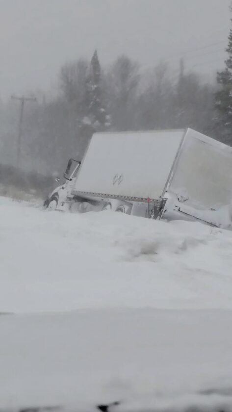
Many vehicles needed to be towed after trying to travel in poor conditions Monday, including this truck in the ditch on M-35 near Rock. (Photo courtesy of Dave Pepin)
The Delta County Landfill closed Monday, necessitating some schedule-shuffling. Delta Disposal announced that their services — both trash and recycling collection — will be delayed one day through Saturday. If side roads are inaccessible, further delays may occur. In the City of Escanaba, commercial recycling pickup will be Wednesday; Monday’s, Thursday’s and Friday’s routes will all be delayed by one day; and today’s route will be completed Thursday.
As the week continues, some minor snowfall is likely, though not with much more accumulation. Temperatures will be slightly chillier; from Tuesday through Friday, highs will be about 20 degrees Fahrenheit, and the lowest single-digit temps may be experienced Wednesday, Thursday and Friday nights. On New Year’s Eve night — Wednesday — the NWS predicts a low of zero.
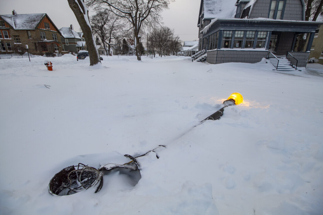
On Monday, a downed but illuminated lightpost on South Seventh Street in Escanaba lies in the snow. (R. R. Branstrom | Daily Press)

This image on weather.gov shows reported snowfall amounts in the central Upper Peninsula. A range of recordings, even in the same towns, indicates the variation in depth caused by high winds.
Homes and businesses in the Upper Peninsula and the northwestern Lower Peninsula lost power from the storm that hit the area Sunday night into Monday. (Image from poweroutage.com)
Local News
Origins of First Presbyterian Church date back to 1860s
Year in Review: Second quarter of 2025
ESCANABA — As we prepare to usher in a new year, the Daily Press is looking back on top stories from 2025. ...
New airline service to be added in Marquette County
MARQUETTE — Travel Marquette has announced that beginning May 21, United Airlines will offer three daily direct ...
No Daily Press on New Year’s Day
ESCANABA — With no mail delivery on New Year's Day, the Daily Press will not have a newspaper Thursday. The ...

MSP: Alcohol-related car crashes down but not by much